Day 134 (November 9, 2018) – Aguas Calientes, Perú
This was and will probably remain one of the greatest
hikes we’ve ever done. We took nine days to hike from a trail head outside of a
town called Cachora through to the Inca ruins of Choquequirao and onward to
Machu Picchu. This took us over 120 km and up and down mountains having over 6,000
meters of elevation gain and 7,000 meters of descent. There was a lot of hiking,
sore legs, some confusion and uncertainty, but a lot of satisfaction from the
breathtaking scenery, mysterious Inca ruins, and of course, finally finishing.
 |
| Not much going on in Cachora, but it was the start of our trail. |
Our trip started in Cusco after we collected all the gear
we needed. We took a 4-5-hour bus ride out of town, through the mountains, and
got off at a non-descript highway turnoff to Cachora. After arguing for a while
on the price of a taxi, we finally got in and took the 30-minute ride down the
mountain from the highway to our hotel in town. Our original plan was to leave
on the hike the next morning, but we had some important errands to run and it
was starting to get dark. We delayed the errands to the next day and spent the
night after having a meal of egg and rice. This was our first of what would be
many plates of egg and rice. It’s about as exciting as it sounds. One fried egg
next to a small mound of white rice. If we were lucky there would be some salt
on the table.
 |
| The main square of Cachora. We hired a mule from the house in the back right corner. The mountains in the distance were stunning, but they were usually covered in clouds. |
The next day we went into the town center to hire a mule
and muleteer to transport our equipment for the trek. We could have carried our
own gear in a pack, but we (wisely) decided not to do this. We didn’t know how
one is supposed to go about hiring a mule, but it wasn’t long before someone
came up to us and offered their services. After talking to a couple people, we
successfully negotiated an itinerary and a price for the hire of a mule and
muleteer. I think this was one of the highlights of our Spanish speaking
accomplishments. We never would have been able to do that when we first started
back in Guatemala. We were essentially paying around $30 a day for our gear to
be taken from one campsite to the next along the trail while we carried a day
pack. The service was worth every penny.
 |
| The view from Capuliyoc in the early morning. Most mornings looked like this with clouds clinging to the mountains. |
With all our errands taken care of, we got up early the
next day and took a 30-minute taxi ride to the start of the trail head at Capuliyoc.
We arrived and got our first sights of the mountains we’d be hiking through,
which in the early morning were covered in low lying clouds. We
were the first hikers to arrive, but we ended up waiting there for a
couple hours until the mule and our muleteer, Lucio, finally showed up. We were told not to
worry about the wait, but so much for our early start.
 |
| The muleteers prepping the mules at the start of the trail head. |
 |
| The trail down to the river. |
The hike to Choquequirao is surprisingly straightforward.
It’s along a well-worn mule trail and nearly impossible to get lost. On day
one, we started near the top of a mountain in Capuliyoc, as far as any road can
take you towards Choquequirao. We hiked along and down the mountain all the way
to the Apurimac River 1,400 meters below. After a rest at the bottom, we
escaped the ruthless bugs and started ascending the mountain on the other side.
The whole trail is steep switchbacks the entire way. No steps,
just a steep incline up or down. No part of the trail is flat. The path is not
designed for enjoyment, but rather for efficiency in getting across the steep mountains.
After ascending a third of the way up the other side we called it a night at a
campsite called Santa Rosa Baja.
 |
| Switchbacks on the way down. |
 |
| Finally made it down to the river. |
 |
| And back up the other side. |
Our first campsite was like all the others. Nothing
fancy. Just some areas of flat ground to set up a tent. Cold showers and
somewhat frightening toilets, but we got used to both. We could also buy plates
of food. Everywhere we went it always seemed to be the same: egg and rice. The
really good campsites would add in something else, either polenta or slices of
hot dog. We bought food often at the beginning because we wanted to make sure
the 5 days of food we brought with us would last us to the end of the trek. One
of the worst parts of hiking was being exhausted and still having to set up our
tent. It soon became routine, however, and we got quite good at it, but it took
a few nights to get our routine down. We never had any issues sleeping. We were
always too damn tired.
 |
| Getting our bags prepped at the shelter at Santa Rosa Baja. |
On the morning of day two we woke up to our muleteer
banging on our tent to wake us up. We exit the tent and find we’re one of the
last to leave for the day. We were so tired we didn’t even notice people were
getting up. We hiked the rest of the way up the mountain, through the small village
of Marampata, and finally got our first sight of Choquequirao. It was a cruel
joke because even though we could see where we were going it was still half way
around the mountain and took seemingly forever to make it to the Choquequirao
camp site. We even took a hike down to our first set of Incan terraces. When we
made it back to the campsite that evening everything was hurting, and sleep
came very easily.
 |
| At the edge of the terraces that are barely hanging on to the cliff sides. |
 |
| The Choquequiarao ruins are spread out over a mountain top. A couple sets of terrace ruins and the campsite are on this side. The building is where the excavation workers stay. The main set of ruins are at the top of the mountain and there are further ruins back down the other side. Hiking all over the steep mountain sides is not easy. |
 |
| An Incan house on top of a mountain. |
 |
| The view from the top of the ruins down into the valley. |
 |
| The flattened mountaintop of the Choquequirao ruins. |
 |
| The iconic buildings of Choquequirao. |
Day three was our day to explore the Choquequirao ruins
and relax a bit. It turned out that relaxation wasn’t on the agenda. The
Choquequirao ruins are so spread out that you need to hike all over the top and
sides of a steep mountain to see them. The ruins were pretty cool to see. There
really weren’t that many people around and you can go anywhere you like in
them. We had lunch looking out over the main square lined with buildings and
water ways. You could also see for miles from just about anywhere in the ruins.
The Inca picked a beautiful location to live, but they needed some serious
determination to make it work on top of this mountain. We ended the day totally
wiped out and exhausted. We made our own dinner that night, which anytime on
this trail was either ramen with tuna or chicken-flavored rice with eggs or
smoked sausage. Although nothing fancy, it was tastier than egg and rice. Our
day in Choquequirao felt like any other hiking day, but seeing the ruins was a
great experience and a nice reward for our efforts.
 |
| The famous white llama terraces. Hiking down to them was a bit painful. |
 |
| The ruins are extensive and most of them are still buried. |
 |
| Enjoying the view at the top of the Choquequirao ruins on our way out. We had to hike down from here to the river and up the mountain on the other side. All in one day. We had an early start. |
 |
| One of our last views of the ruins near the Choquequirao pass. |
Day four was by far the hardest hiking day. We got up before
dawn, had to hike back up to the ruins and over the Choquequirao pass at 3,300
meters. Then we had to hike all the way down an entire mountain to Rio Blanco
at 1,900 meters, only to head back uphill all the way to the top of a second
mountain at 3,000 meters. We were hiking uphill forever. Steep switchbacks and
blazing sun the entire way on the uphill. It was hot, exhausting, and horrible.
The views, however, were stunning. We camped at someone’s house in the “town”
(aka. two houses on a mountain) called Maizal. The facilities left a lot to be
desired, but the view was incomparable. You could see everything from glacier-capped
peaks to the rivers a thousand meters below.
 |
| The endless switchbacks up to Maizal. |
 |
| The views were always amazing, but also frightening to think that we had to hike up and down these mountains. |
 |
| Made it down to the Rio Blanco. It was a hundred degrees down here. The river is larger than it looks. The big boulders are the size of small cars. |
 |
| This pretty much sums up how we felt on the way to Maizal. And this was us when we were happy after reaching an elevation where trees started growing again and could provide some brief shade. |
 |
| The view up to Maizal. |
On paper, day five was one of our easier hiking days, but
in practice it was very difficult (at least for me). I had no energy that day.
I felt like I had exhausted everything I had to give in the days prior. We’ve
learned that for no rhyme or reason, some days you just wake up and hiking is
difficult, and energy is hard to come by. We pressed on anyway and continued
hiking uphill to Victoria Pass at 4,200 meters and then downhill 500 meters to the
village of Yanama. This was a huge accomplishment for us because we had
officially finished the Choquequirao portion of the hike, and we could have
taken a car to Machu Picchu from this point if we really wanted. However,
having gone this far, we elected to press onward. Our legs were getting used to
the abuse and, although hiking was always difficult, it wasn’t as painful as it
had been the first couple days.
 |
| Original Inca trail near the Victoria Pass. We were stuck hiked in clouds all morning. |
 |
| Hiking on top of the clouds. |
 |
| Hiking along mountainsides. It was better to just keep walking and not think about the cliffs too much. |
Day six was a ridiculously long day. We got up the
earliest we ever had and set off in the early dawn with a few hard-boiled eggs for
our breakfast on the go. Is was both the most pleasant and the worst hiking day
of the trek. The hike in the morning was easy and beautiful as we slowly
climbed out of an insanely picturesque valley and up to the Yanama Pass at
4,640 meters. This part of the hike reminded me that hiking can actually be
enjoyable at times. Unfortunately, it wasn’t that much later that our ascent
took us up into the rain clouds that clung to the mountain tops. Walking
through the Yanama Pass was the worst experience of the hike. It was raining
hard and the wind was so intense it was hard to walk. It was like walking
through a car wash where they left the rinse and air-dry cycles on at the same
time, all while cranking up the air conditioner. We were completely drenched
and freezing. We had to stop and huddle under a rock to pull out warmer clothes
and to try and warm ourselves up. I was expecting a great sense of
accomplishment after having reached the highest elevation of our hike, but instead
we both just felt a little fearful for our lives and wanted to run down the other side of the mountain as fast as our legs would take us. As we descended, it did warm up
slightly, but the rain never stopped. We spent the day freezing and wet. However,
there was a pleasant surprise. We met one of our hiking companions and our
muleteer at a woman’s house along the way where she served hot coffee and
delicious soup. It was one of the most pleasant surprises of the trip. We ended
the night at a campsite in Colcapampa at 2,870 meters.
 |
| Hiking through the valley out of Yanama. This was the nicest and easiest part of the trail. |
 |
| Hiking to La Playa. It was the most boring day of the trail, but at least it was mostly flat or downhill. |
 |
| Back down at a river again. |
 |
| We were able to get our first real cup of coffee in a long time at La Playa. |
Day eight was another challenging day, but our last day
of having to cover a significant distance. We hiked from La Playa up and over
900 meters of a mountain to Hydroelectrica. The mountain was the easy part. The
hard part was that the courier service for our equipment ended in
Hydroelectrica. This is the last stop that any car can go into Aguas Calientes,
the home base of Machu Picchu. You either take a train or walk from here.
Naturally, we chose to continue walking. I wasn’t about to hike this far and then
hop on a train. So, we had be our own mule and hike along the train tracks with
all our stuff to the campsite at Aguas Calientes. Our equipment was not in bags
conducive to carrying it, but we lugged it anyway. With our heavy and awkward
belongings on our back this felt like the longest part of the trek even though
we were only going a few kilometers. We collapsed after making it to the Aguas
Calientes campsite at the base of Machu Picchu.
 |
| Our first hazy view of Machu Picchu from across the mountains. |
 |
| The view from the pass, looking down towards Hydroelectrica. |
 |
| Walking across the suspension bridge over to Hydroelectrica. |
 |
| Our first sign for Machu Picchu. |
 |
| Feeling tired at Hydroelectrica. Behind is the train to Aguas Calientes we elected not to take. |
 |
| Aguas Calientes. |
Our last day, day nine, was a busy day. We walked to
Aguas Calientes to buy afternoon entrance tickets to Machu Picchu and train
tickets out of town for that night. We then walked back to our campsite,
gathered a few items, and started hiking uphill to Machu Picchu. The hike
wasn’t that far, only 400 meters of elevation gain, but it was packed with
people. We finally made it to the entrance to the ruins and you could hardly
get anywhere there were so many people, most arriving by bus. We toured the
ruins and while Machu Picchu was incredibly picturesque and fascinating, we
couldn’t get past all the people who where there. It felt too crowded and there
is a specific path you’re allowed to follow through the ruins. It kind of felt
like we were on a huge tourist conveyor belt. I wouldn’t say that Machu Picchu
was a let-down, but it was not the highlight of the trek. Back at camp, we
packed everything up and headed into Aguas Calientes for our first real dinner.
We were so hungry we had two dinners. We ate an entire pizza with couple beers,
and then went to a pub and ordered a burger and milkshakes. Afterwards we
boarded a train out of Aguas Calientes and onward to our next stop in
Ollantaytambo, where a real bed and hot showers awaited.
 |
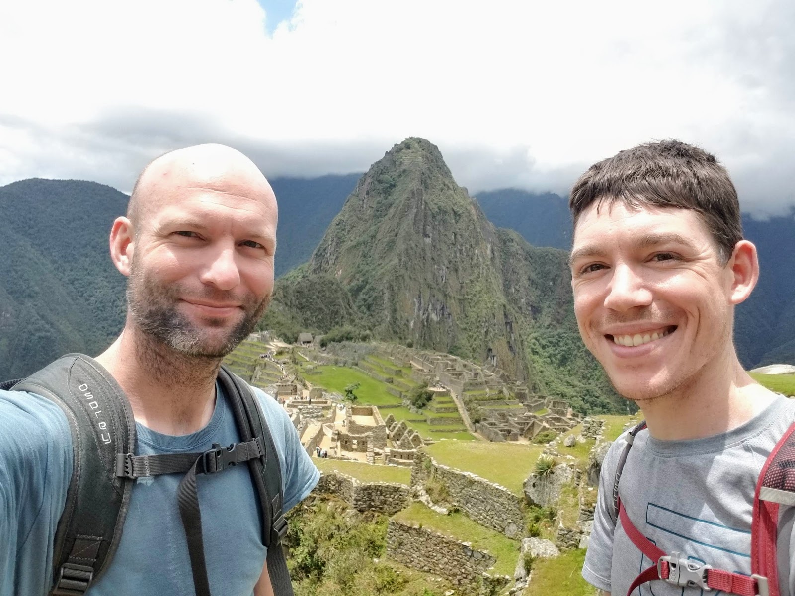
| Nine days after we started we made it to Machu Picchu. |
 |
| Machu Picchu is incredibly photogenic. |
 |
| Crowds of people all trying to get the perfect Machu Picchu pic. |
 |
| One of the ceremonial rocks. Not too much is really known about most things at Machu Picchu. |
 |
| The stonework is really quite impressive. Some of it was built right on top of the existing rock. |
 |
| Watching the train run through the center of Aguas Calientes while we had our first dinner. |
For this trip it really was about the journey and not the
destination. Choquequirao and Machu Picchu were very interesting to see, but
they’re not what I’ll remember most. I will remember more the endless hiking
along mountain edges, trains of mules carrying gear passing us up on the trail
and muleteers running to keep up with them, sleeping in our bright yellow tent,
waking up to cold and cloudy mountains, meals of tuna and ramen, utter
exhaustion after finally reaching our campsites, and how at the right time the
tastiest thing in the world is a chocolate bar. It was the trip of a lifetime
and one that I’m so glad we did, but I also have no desire to go back and do that all over again.
 |
| Us with Lucio and the mule in Colcapampa. |


Comments
Post a Comment